In this field note12 sections +Close −
- 012026 Broad Peak Avalanche
- 02In this field note
- 03What happened in the 2026 Broad Peak avalanche?
- 04How many climbers died?
- 05Was Nirmal Purja killed in the Broad Peak avalanche?
- 06Where did the avalanche occur?
- 07What caused the Broad Peak avalanche?
- 08Were other climbers concerned about the conditions?
- 09Was the avalanche related to climate change?
- 10Were all the bodies recovered?
- 11Can an avalanche on Broad Peak be predicted?
- 12Does an experienced climber eliminate avalanche risk?
2026 Broad Peak Avalanche
On 30 July 2026, an avalanche swept across Broad Peak during an ascent between Camp 2 and Camp 3, carrying a ten-member international expedition down the mountain.
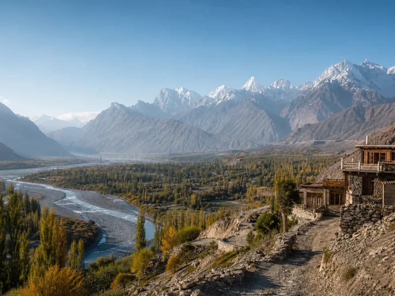
Broad Peak rises to 8,051 metres in the Karakoram and stands across the Godwin-Austen Glacier from K2. The avalanche struck at approximately 6,600 metres, well below the summit but deep inside serious high-altitude terrain. All ten climbers were eventually confirmed dead.
The accident was devastating, but the important field question is larger than the list of casualties.
What were the conditions before the avalanche? What did other teams observe? What happened to the rescue effort? Why was recovery so difficult? And what should climbers and expedition operators take from an event in which experience, equipment and preparation could not remove the mountain's objective hazards?
This is Namla's field note on the 2026 Broad Peak avalanche.
In this field note
- The mountain and the route
- What happened on 30 July
- Conditions before the avalanche
- The ten climbers
- The first hours after the slide
- Search and rescue
- Recovery of the climbers
- Why the terrain was so difficult
- What the accident tells us about avalanche risk
- Heavy snowfall and delayed movement
- The climate-change question
- Why experience does not remove objective hazard
- Lessons for Karakoram expeditions
- What operators should be monitoring
- Communication and emergency planning
- Why helicopter rescue is never a guarantee
- The role of local mountain teams
- What this means for future Broad Peak expeditions
- Questions climbers should ask before an expedition
- FAQ
- Namla field note
- Conclusion
01. The mountain and the route
Broad Peak is one of the world's fourteen 8,000-metre peaks, reaching approximately 8,051 metres. It is the world's twelfth-highest mountain and lies in the central Karakoram, close to K2.
From below, Broad Peak can look deceptively straightforward compared with the steeper faces of neighbouring K2. That comparison is misleading.
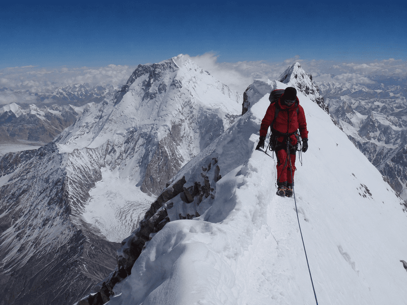
High-altitude climbing on Broad Peak still involves glaciers, steep snow and ice, exposed terrain, objective avalanche danger, rapidly changing weather, altitude and limited rescue access.
The 2026 accident occurred around 6,600 metres on the mountain section between Camp 2 and Camp 3. This matters operationally because an avalanche in that zone is not simply an inconvenience on a climbing route. It is a high-consequence event occurring far above Base Camp, where evacuation, communication and access become progressively more difficult.
Field note: A route is never defined only by its map line. Snow loading, wind, temperature, seracs, cornices, crevasses and recent avalanche activity can change what the route actually is from one day to the next.
02. What happened on 30 July 2026
At approximately 9:30 a.m. local time on 30 July, an avalanche struck ten climbers moving toward the upper camps.
The group was on the section between Camp 2 and Camp 3. Tracking data from satellite devices showed abrupt and substantial loss of elevation after the avalanche. Nirmal Purja's tracker indicated a fall of roughly 800 metres, while other climbers were carried much farther down the mountain.
The avalanche swept all ten climbers from the slope.
The first reports were necessarily incomplete. Search teams initially worked with the possibility that some climbers might have survived. As the terrain was searched and tracking information was compared with visible debris, the scale of the accident became clearer.
By 1 August, Purja's expedition organization had confirmed that the climbers had not survived.
Later recovery operations located the remaining victims.
The final missing climber, American Mallory Geis, was located by local volunteers on 21 August, bringing the search for all ten victims to its final stage.
03. Conditions before the avalanche
The most important part of this accident may be what happened before 30 July.
Reports from climbers already on Broad Peak described deteriorating conditions in the days before the avalanche. Heavy snowfall began around 22 July, following a period in which some climbers had initially considered avalanche danger relatively low.
David Klein, who had been climbing Broad Peak earlier in the season, described the problem in practical terms: after significant snowfall, clear weather alone does not immediately mean the mountain is ready for movement. Newly deposited snow has to bond to the underlying surface or release.
Several expeditions left the mountain as conditions worsened. National Geographic reported that most teams at Base Camp had departed by 25 July, while a smaller number remained.
This does not establish that the avalanche was caused by a single decision or that another decision would necessarily have prevented it.
It does establish something simpler and more important:
The mountain was showing warning signs before the accident.
The existence of warning signs and the ability to predict exactly when a specific avalanche will occur are two very different things.
04. The ten climbers
The expedition members came from several countries and included elite high-altitude climbers, professional guides and climbers pursuing major personal objectives.
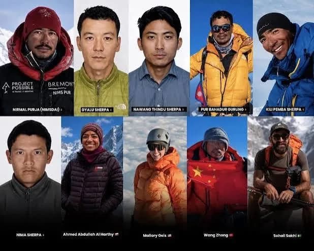
The ten people killed were:
Nirmal “Nimsdai” Purja
Nepal / United Kingdom
Pur Bahadur Gurung “Yukta”
Nepal
Nima Sherpa
Nepal
Kili Pemba Sherpa “Kilu”
Nepal
Nawang Thindu Sherpa
Nepal
Gyalu Sherpa
Nepal
Wang Zhong
China
Nadhira Al Harthy
Oman
Sohail Sakhi
Pakistan
Mallory Geis
United States
Several of those lost were experienced Sherpa high-altitude workers. Pur Bahadur Gurung was an IFMGA-certified guide, while Kili Pemba Sherpa had been part of the team that made the first winter ascent of K2 in 2021.
Nadhira Al Harthy had previously climbed Everest, K2 and Manaslu and was the first Omani woman to summit Everest.
Sohail Sakhi was a highly experienced Pakistani mountain guide.
The accident therefore cannot be reduced to a simple story of inexperienced people entering terrain they did not understand.
That distinction matters.
05. The first hours after the slide
Satellite trackers became important because they provided information about where climbers had been before and after the avalanche.
Purja's tracker was transmitting from around 6,166 metres at 5:33 a.m. on the morning of the accident. The team continued ascending during the morning before the avalanche occurred.
After the slide, tracking data indicated dramatic downward movement.
Some climbers were carried hundreds of vertical metres. Purja's tracker showed an approximately 800-metre loss in elevation. Other devices indicated that climbers had been swept much farther down the mountain.
Tracking technology can help locate people after an accident, but it does not solve the physical problem.
Knowing the coordinates of an injured or deceased climber at 5,800 or 6,000 metres is useful only if a trained team can physically reach that position.
In the Karakoram, those are two different problems.
06. Search and rescue
Aerial and ground searches began after the accident.
Two helicopters participated in an aerial search on 31 July, while ground teams approached from lower camps. Drones were also used to identify possible bodies and debris across the avalanche area.
The search was complicated by weather, altitude and terrain.
Aerial rescue is particularly dependent on weather conditions, visibility, wind, aircraft capability and the ability to establish a safe landing or extraction sequence. A helicopter cannot simply hover over any location on an 8,000-metre mountain and remove a patient.
Ground teams therefore remained critical.
The Alpine Club of Pakistan coordinated parts of the search, while Pakistani, Nepali and other mountaineering personnel contributed to the recovery operation. Teams from nearby expeditions, including climbers on K2, interrupted their own plans to assist with the search.
07. Recovery was an expedition of its own
The initial response was a rescue operation.
Once it became clear that there were no survivors, the operation became recovery.
That distinction is important because recovery at extreme altitude carries its own risks.
Bodies and equipment were distributed across a large debris area. Some locations were accessible from lower ground; others were exposed to further avalanche and serac danger.
On 2 August, a Nepali-Pakistani team located and recovered the remains of Nirmal Purja, Wang Zhong, Nima Sherpa and Kili Pemba Sherpa at around 5,700 metres.
Sohail Sakhi's remains were eventually located later in August.
Mallory Geis, the last missing member of the team, was located on 21 August by local volunteers.
The fact that the recovery continued for weeks shows the scale of the terrain and the constraints facing rescue teams.
08. Why the terrain was so difficult
An avalanche on a high-altitude mountain creates more than one hazard.
The initial slide can:
- bury climbers
- carry people over cliffs and rock
- destroy equipment
- separate team members over a large area
- damage fixed ropes
- alter the route
- expose rescuers to secondary avalanches
- create unstable debris fields
At approximately 6,600 metres, rescuers are also working in an environment where ordinary human movement is already severely affected by altitude.
The result is a difficult equation:
Less oxygen + steep terrain + unstable snow + weather + distance = very limited rescue margin.
That is one reason emergency planning must happen before an expedition leaves Base Camp, not after an incident begins.
09. What the accident tells us about avalanche risk
Avalanche danger is not a simple weather symbol.
A forecast may show relatively calm conditions while the snowpack remains unstable.
Recent snowfall is important because new snow adds load to existing layers. Wind can transport snow into slabs and loaded slopes. Temperature changes can alter bonding and surface conditions. Cornices and seracs can also fail independently of the immediate weather at the climber's position.
For an expedition team, the relevant question is therefore not:
“Is the weather good today?”
It is:
“What has happened to the mountain during the last several days, and what does that mean for the route we intend to cross today?”
That is a very different question.
10. Heavy snowfall and the waiting problem
Heavy snowfall creates a dangerous temptation in expedition climbing.
The weather clears.
The sky becomes blue.
The summit window appears.
The team feels pressure to move.
But the snow does not necessarily become safe simply because precipitation stops.
Climber David Klein described the problem directly after the 2026 Broad Peak conditions deteriorated. Following heavy snowfall, he said climbers need a period without additional snowfall so the new snow can settle, bond or release before movement resumes.
The exact time required varies with terrain, temperature, wind, snow structure, aspect and altitude.
There is no universal “wait 24 hours” rule that converts a loaded slope into a safe slope.
This is why local observation and continuous route assessment remain essential.
11. The climate-change question
The Broad Peak accident has also generated a larger discussion about changing conditions in the Karakoram.
That discussion needs care.
It is not currently possible to say that climate change directly caused the July 30 avalanche.
A recent analysis published by Dawn noted that there is no evidence yet establishing a direct climate-change cause for this specific event. Pakistani mountaineers interviewed for the report instead pointed to immediate factors such as heavy snowfall and changing snow conditions, while noting wider changes occurring across the mountain environment.
The broader environmental trend is harder to dismiss.
Glacier retreat, changing snow patterns, changing meltwater, exposed rock, shifting crevasse systems and altered seasonal behaviour can all affect mountaineering routes over time.
For climbers, the practical point is not to turn every avalanche into a climate argument.
It is to recognize that historical route knowledge is not a guarantee that today's route behaves like yesterday's route.
12. Experience does not remove objective hazard
The Broad Peak accident is uncomfortable precisely because the people involved were not simply unprepared amateurs.
The expedition included professional guides and highly experienced high-altitude climbers.
This does not mean preparation is pointless.
It means preparation has a limit.
Objective hazards such as:
- avalanches
- falling seracs
- rockfall
- cornice collapse
- crevasse collapse
- sudden storms
- extreme cold
- altitude
cannot be completely controlled by the climber.
A strong expedition system does not promise to eliminate these hazards.
It tries to reduce unnecessary exposure to them.
That distinction is central to serious mountaineering.
13. Lessons for Karakoram expeditions
The 2026 Broad Peak avalanche reinforces several operational principles that apply well beyond Broad Peak.
Watch the mountain, not only the forecast
A forecast is one information source.
Guide observations, recent snowfall, wind loading, visible avalanche activity, route changes and conditions reported by teams returning from higher camps can be equally important.
Build rest and weather days into the plan
A schedule that has no room to wait is not really a schedule.
It is a deadline wearing mountaineering clothing.
Reassess routes after snowfall
A route that was safe two days earlier may not be the same route after heavy precipitation and wind loading.
Keep summit decisions reversible
A team should be able to turn around without the decision being treated as a failure.
Plan for evacuation before the emergency
Knowing who to call, what information is required, which aircraft resources may be available and where a ground evacuation could begin should be established in advance.
Do not confuse technology with rescue capability
Satellite trackers, GPS devices, weather forecasts and satellite phones improve information.
They do not remove terrain.
14. What operators should be monitoring
A serious high-altitude operator should continuously monitor more than weather.
Before a summit push, teams should be reviewing:
Recent snowfall
How much snow has accumulated and over what period?
Wind loading
Has wind transported new snow onto the intended route?
Avalanche activity
Have natural avalanches been observed nearby?
Cornices and seracs
Are large overhead structures becoming visibly unstable?
Temperature trends
Has there been an unusual warming or cooling period?
Visibility and cloud
Can the route and surrounding avalanche terrain actually be assessed?
Route changes
Have crevasses, snow bridges or fixed lines shifted?
Team condition
Are climbers making safe decisions, or are fatigue and altitude affecting judgement?
The point is not to create a mathematical score that pretends a mountain can be reduced to a dashboard.
The point is to combine multiple pieces of evidence before committing people to serious exposure.
15. Communication and emergency planning
An expedition communication system should assume that something may fail.
Satellite communication can become unreliable.
A device can be lost.
A battery can die.
A person can become separated from the group.
A helicopter can be grounded by weather.
The emergency plan should therefore include:
A primary communication system.
A backup communication method.
Known emergency contacts.
A clear chain of decision-making.
Current team and passport information.
Location information from tracking devices.
Medical and evacuation details.
Ground evacuation options.
Family and embassy contact procedures where appropriate.
The objective is not bureaucracy.
In remote mountains, administration becomes part of rescue infrastructure.
Namla already treats permits, emergency procedures, staff logistics and field communications as connected parts of expedition planning rather than separate paperwork exercises.
16. Why helicopter rescue is never a guarantee
The Broad Peak recovery again demonstrated a basic rule of Karakoram expedition planning:
A helicopter is a resource, not an insurance policy.
Helicopter operations depend on weather, visibility, wind, altitude, aircraft limitations, available crews, landing or hoist conditions and the physical location of the casualty.
A helicopter may be able to reach one location and be unable to reach another only a few hundred vertical metres away.
This is why expedition systems should be built around prevention first, field treatment second and evacuation options third.
Namla's existing Field Notes make the same operational distinction: rescue in the Karakoram begins long before a helicopter is requested.
17. The role of local mountain teams
One of the less discussed parts of the Broad Peak aftermath was the role of local people in the recovery effort.
Searches were carried out by professional teams, mountaineers, military aviation resources and local mountain personnel.
Later in August, local volunteers were also involved in locating the remaining victims, including Sohail Sakhi and eventually Mallory Geis.
This is consistent with a broader reality of Karakoram expeditions.
Maps, satellite imagery, weather models and GPS devices provide information.
People provide context.
They know access routes, local conditions, villages, terrain, seasonal changes and practical logistics.
The technology is useful.
It is not a substitute for mountain knowledge.
18. What this means for future Broad Peak expeditions
The 2026 accident does not mean Broad Peak becomes an impossible mountain.
It does mean that future teams need to approach its route as a dynamic high-altitude environment.
Expedition plans should leave room for:
- changing camp positions
- route inspection
- waiting after major snowfall
- altered snow bridges
- changing avalanche terrain
- poor flying weather
- additional acclimatization
- evacuation delays
- recovery or turnaround decisions
The correct operational response to a tragedy is not to declare that a mountain is safe or unsafe forever.
It is to improve how decisions are made on that mountain.
19. Questions climbers should ask before an expedition
Before joining a high-altitude expedition in the Karakoram, a climber should be able to get clear answers to practical questions.
Who is responsible for the expedition's field decisions?
How are weather and route conditions monitored?
What happens after heavy snowfall?
Who assesses avalanche exposure?
What communication devices are carried?
What is the ground evacuation plan?
What happens if helicopters cannot fly?
How are staff and high-altitude workers protected?
What insurance applies to evacuation and rescue?
Who communicates with family members during an emergency?
These questions are not signs of distrust.
They are signs that everyone understands the mountain is not a controlled environment.
20. FAQ
What happened in the 2026 Broad Peak avalanche?
On 30 July 2026, an avalanche struck ten climbers ascending between Camp 2 and Camp 3 on Broad Peak at roughly 6,600 metres. All ten were eventually confirmed dead.
How many climbers died?
Ten climbers died in the accident.
Was Nirmal Purja killed in the Broad Peak avalanche?
Yes. Nirmal “Nimsdai” Purja was among the ten climbers killed. His death was confirmed by his expedition organization on 1 August.
Where did the avalanche occur?
The avalanche struck the mountain between Camp 2 and Camp 3 at approximately 6,600 metres.
What caused the Broad Peak avalanche?
The precise trigger has not been definitively established. Reports documented heavy snowfall and unstable conditions in the days before the accident, but that does not by itself establish a single causal factor.
Were other climbers concerned about the conditions?
Yes. Reports from climbers who had already been on the mountain described increasing concern after heavy snowfall, and several expeditions had departed before the avalanche.
Was the avalanche related to climate change?
There is no established evidence that climate change directly caused this specific avalanche. Broader climate-related changes are affecting mountain environments across the Karakoram, but separating long-term environmental change from the immediate causes of one avalanche requires evidence specific to that event.
Were all the bodies recovered?
The final missing victim, American climber Mallory Geis, was located by local volunteers on 21 August, completing the search for the ten-member team.
Can an avalanche on Broad Peak be predicted?
Avalanche risk can be assessed, but the exact timing and release of a specific avalanche cannot be guaranteed. Snowfall, wind loading, snowpack structure, terrain and temperature all interact.
Does an experienced climber eliminate avalanche risk?
No. Experience improves decision-making, route assessment and risk management, but it cannot eliminate objective hazards.
21. Namla field note
There is a temptation after an accident like Broad Peak 2026 to search for one mistake, one forecast, one decision or one person that explains everything.
Mountains rarely cooperate with that kind of neat explanation.
The field reality is usually more complicated.
Snow accumulates.
Wind redistributes it.
Temperatures change.
Routes evolve.
Climbers become tired.
Weather windows narrow.
Plans become psychologically important.
And then the mountain can change faster than the people on it can respond.
The practical lesson for us is not that expedition climbing should be treated as a game of predicting exactly when disaster will happen.
It is that good expedition work creates more opportunities to observe, wait, reassess and turn around.
That requires planning before the expedition, competent people in the field, realistic schedules, local knowledge, reliable communications and the discipline to treat a changing mountain as a changing mountain.
22. Conclusion
The Broad Peak avalanche of 30 July 2026 was a profound loss for the international mountaineering community and for the families and communities connected to the ten climbers who died.
It also became a long recovery operation, requiring aerial searches, ground teams, climbers from neighbouring expeditions, local personnel and volunteers working in difficult conditions.
Broad Peak remains what it was before the accident: an 8,000-metre mountain in an environment where snow, ice, weather, altitude and terrain impose limits that no operator can negotiate away.
For future expeditions, the responsibility is not to promise certainty.
It is to prepare carefully, watch the mountain continuously, respect changing conditions and make decisions that leave room for the mountain to say no.
The route is never just the line on the map.
End of field note
Continue your research.
Browse all notes